WEED project
The World Ecosystem Extent Dynamics (WEED) project is developing a globally applicable open-source toolbox, leveraging existing datasets and tools while applying creative and novel methods to use Earth Observation (EO) enabling countries and other stakeholders to generate comprehensive high-resolution (10-30 m) maps of the ecosystem distributions of terrestrial, freshwater, and coastal ecosystems (up to intertidal) types and their temporal variations according to different ecosystem typologies (IUCN Global Ecosystem Typology (GET), European Nature Information system (EUNIS) and ecosystem extent typology EU-ET); with the option for crosswalks with national or other typologies (e.g. Ramsar, EU Habitats Directive Annex I), with direct applicability for policy applications (GBF A.2, SEEA EA, TNFD).
The WEED toolbox is being developed in collaboration with users, while liaising with key international initiatives and key international stakeholders. As such, it is considered as a contribution to international efforts to map ecosystem extent. The WEED project is split in two phases: the first phase (September 2024 - April 2026) focuses on user co-creation of the solution/toolbox with six countries (Champion Users); the second phase (May 2026 - March 2027) focuses on user uptake to validate the toolbox results with eleven countries and at EU continental scale.
Policy Applications
The robustness and transferability of the toolbox and its system will be demonstrated to scale to larger areas (national and European continental) and will showcase the use of its results (maps and tables) for various policy applications including Ecosystem Accounting, the Global Biodiversity Framework and the RAMSAR convention, and can be also applicable to other users such as the businesses and financial communities.
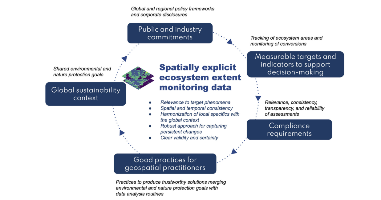
Conceptual scheme of compliance drivers for ecosystem extent data in a global monitoring context
Ecosystem Extent as a Foundation for Environmental Policy and SEEA-Aligned Reporting
Ecosystem extent—the area and distribution of different ecosystem types—has become a central building block for global sustainability assessments. It supports efforts to understand ecological conditions, track ecosystem change, and measure progress toward national and international biodiversity commitments. The System of Environmental‑Economic Accounting – Ecosystem Accounting (SEEA EA) provides the main global standard for organizing this information, requiring consistent reporting of opening and closing extents and clear tracking of transitions between ecosystem types, including distinctions between managed and unmanaged changes. This standardized approach is increasingly embedded in global frameworks such as the Global Biodiversity Framework (GBF), and it is also essential for ecosystem‑specific monitoring under the Ramsar Convention, which requires countries to track the extent and recent changes of wetlands as part of their international reporting obligations. Together, these frameworks highlight the growing need for harmonized, high‑quality ecosystem extent information across the policy landscape.
A Cross‑Cutting Enabler for Climate, Biodiversity, Land Management, and Restoration Targets
Accurate and harmonized ecosystem extent data plays a crucial role far beyond biodiversity reporting. It supports:
-climate‑related inventories, including land‑based greenhouse‑gas accounting under AFOLU and LULUCF
-land degradation neutrality assessments
-agricultural sustainability monitoring
-conservation and restoration policies spanning forests, wetlands, coasts, and marine ecosystems
Policymakers increasingly rely on spatially explicit ecosystem information because it complements traditional land‑use and land‑cover datasets with ecological meaning. To function across these diverse applications, ecosystem extent products must be aligned with robust classification systems—such as the IUCN Global Ecosystem Typology or national typologies cross‑walked to it—and meet high standards of accuracy, temporal consistency, validation, and uncertainty reporting. These qualities make ecosystem extent datasets a true ‘cross‑cutting’ indicator capable of supporting multiple environmental agendas simultaneously.
Growing Expectations for Companies: Ecosystem Extent in Corporate Sustainability Reporting
Businesses are now expected to measure and disclose their impacts on ecosystems in ways that are consistent, transparent, and aligned with global nature‑positive goals. Leading reporting frameworks—including GRI Biodiversity 2024, the Taskforce on Nature‑related Financial Disclosures (TNFD), and the EU’s European Sustainability Reporting Standards (ESRS E4)—all require organizations to report the extent of ecosystems affected by their operations and value chains. This includes quantifying land‑use change, ecosystem conversion, restoration activities, and impacts in biodiversity‑sensitive areas. These standards increasingly point to SEEA EA principles and spatially explicit ecosystem data as the basis for credible disclosures. As a result, companies will need access to high‑quality, validated, and uncertainty‑aware ecosystem extent datasets that follow recognized typologies. This shift marks a broader trend: ecosystem extent is becoming a critical metric not only for governments, but also for investors, sustainability auditors, and any organization seeking to demonstrate alignment with emerging “nature‑positive” expectations.
For a more in-depth explanation of the policy implications of Ecosystem extent mapping in a global monitoring context, see this article.
